




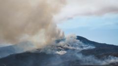
Satellite imagery has confirmed the scale of wildfires spreading across Wales, revealing significant smoke plumes over the Rhinogydd mountains in Gwynedd. Data indicates that approximately 951 hectares have been consumed by fire since early July. NASA’s tracking systems have identified additional heat sources in Blaenavon, Presteigne, and Pentre Halkyn. To assist ground crews, a specialized firefighting helicopter is scheduled for deployment to the Rhinogydd area.
The Welsh government has initiated crisis management protocols to coordinate the response. While several smaller fires have been contained, large-scale blazes in Rhinogydd and Blaenavon remain active. Cabinet minister Siân Gwenllian stated that the Blaenavon fire, which covers 220 hectares, is currently the primary focus for emergency teams operating in difficult conditions. Officials emphasize that despite the heavy smoke affecting visibility and air quality in surrounding areas, there is no immediate threat to life or property.
Authorities have urged the public to avoid restricted areas, warning that entering fire zones is dangerous and may result in legal action. Local police noted that some visitors have required rescue, complicating efforts for emergency services. Residents near active fires are advised to keep doors and windows shut, while commuters are encouraged to use vehicle air recirculation settings to avoid smoke inhalation. Fire services continue to monitor hotspots and maintain containment lines, with additional support from neighboring regions to ensure the blazes do not spread further.