


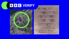
Freshly declassified high-resolution satellite photography has provided an unprecedented look at the destruction inflicted upon various Iranian military and nuclear installations. Planet Labs, a major imagery provider, recently lifted restrictions on over 250,000 photos covering approximately 800 Iranian sites that had previously been obscured due to requests from the United States government.
Analyses performed by BBC Verify and the military intelligence firm Janes highlight significant impact at locations including Esfahan and Bushehr. The imagery reveals extensive damage to ballistic missile infrastructure, ammunition storage, naval bases, and surface-to-air missile sites. According to Janes specialist Jeremy Binnie, the scope of the destruction aligns with reports of a systematic campaign aimed at weakening both Iran’s standing military forces and their supporting infrastructure.
Visible damage is widespread, ranging from collapsed roofs and flattened buildings to sunken naval vessels and cratered runways at Bushehr International Airport. In the Esfahan province, which hosts sensitive nuclear facilities, multiple structures at the Shekari 8 airbase and various surrounding military sites have been either severely compromised or entirely destroyed.
While Planet Labs has loosened its data access, it maintains that restrictions remain active for other regions in the Middle East, citing national security and safety concerns. This limited transparency has historically hindered the ability of independent analysts and humanitarian organizations to verify the consequences of military engagements in the area.